Point Reyes National Seashore

Summer has made it to the Bay Area! Or, at least summer took a day trip to the area on Saturday. After a fairly cool week, Saturday had clear blue skies and temperatures in the mid 80’s… It was perfect weather for a trip to the coast.

Since moving to the Bay Area in 2009, I have become a custom to the large fluctuations in temperature that are quite common here. I routinely leave the house in the morning with jeans and a jacket only to wish I had a T-shirt and shorts in the afternoon, then get left out in the cold again at the late hour of 5PM. I’ve gotten used to this, but not this Saturday.

Looking down the Bear Valley trail

I walked out of the house at 6:30AM in shorts and a light shirt… it was in the 60’s! Much warmer than the usual morning. We arrived at Point Reyes a little after 7:30AM and I started the hike off in shorts and T. Warm weather, a day pack, hiking in Chacos, this was quite a contrast to the multi-day winter trips I had been taking the last few months.

We started up the Bear Valley trail for 0.2mi before turning onto the Mt Wittenberg trail. It was 1.8mi to the summit (1,470 ft). The trail climbed quickly to a small meadow where the summit trail splits off. The summit was another meadow nestled in the trees (not much of a view).

After summiting the mighty Mt Wittenberg, we continued another 0.4mi to pick up the Sky trail towards Woodward Valley (0.8mi). The trail up to Woodward Valley was wide and fairly well maintained. It was also inhabited by several large Banana Slugs.

One of the many Banana slugs crossing the trail. This guy was a good 6 inches long!

Trees left bare by the Vision Fire stand above the new growth

Making the turn onto the Woodward Valley trail, we found ourselves hiking in and out of stretches of trail overgrown by grass and brush (This would have been a nice place to have long pants). The trail descended the ridge about 2mi to the shore, winding its way through the section of the 12,000 acres of wilderness consumed by the Vision Fire in 1995. The new growth was thick, but remnants of the forest  poked through.

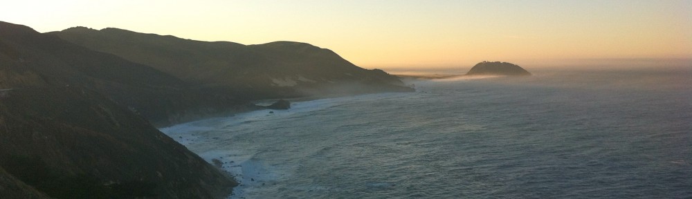
After descending to the coast, we hooked up with the coast trail. This lead us south, winding along the edge of the cliffs for 3.7mi, providing stunning views of the Point Reyes coastline stretching off into the distance. The sky was bright blue and cloud free, but the fog could be seen sitting just above the water a few miles out. It was now about 10:30AM and the sun was quite warm. The gentle breeze coming off the ocean made the temperature quite pleasant.

Heading south on the Coast trail

A little lizard looking good for the camera

The trail alternated between wide, rocky stretches and thick over grown areas. In several of the over grown sections I came very close to stepping on snakes. They seemed a bit camera shy, as they darted into the grass to quick to snap a shot, but they were black with a yellow stripe running their length making me believe them to be a type of garter snake. While the snakes were camera shy, I did catch a lizard striking a pose…

Looking North from Arch Rock

We made it to Arch Rock at about noon, and stopped for a long lunch. The breeze had died, and the sun was beating down from high in the sky. It was definitely time for more sunscreen. We grabbed a spot up the cliff from Arch Rock to get away from the crowd. I spotted a sea lion bobbing in the surf below and we enjoyed a brief visit from a mountain beaver, but he pilled dirt in front of his tunnel opening when the cameras came out.

Arch Rock

Two spiders chillin' in a flowery hangout

After lunch, we backtracked up the coast trail about 0.5mi to pick up the Sky trail. This brought us back up the ridge for 4mi where we followed the Meadow trail 1.6mi down to the Bear Valley trail. The Meadow trail was probably my favorite stretch of trail. It was wide and shaded, winding its way through the trees to the valley. A nice change from the exposed and sometimes densely overgrown Coast and Sky trails.

Once on the Bear Valley trail, it was only 0.8mi back to the car. Here, we were in the company of the large crowd that had been drawn outside by the beautiful weather. It was a great day for a hike.

It was now about 4:30PM, and with about 16mi of hiking in our legs, we made our way south on Highway 1 to Bolinas to grab a beer at Smilies Bar. After a beer and a short walk through town, it was back to the East Bay for a shower… I hope there will be more days like this coming our way!

You can check out more photos on Flickr!

Trail Map

Winter Wonder Land

Be sure to read about the first half of this trip! Snowshoeing in Yosemite, Days 1 & 2

Its Snowing! (Sunday, March 25)

Snow starting to accumulate on the tent.

I awoke early Sunday morning to the sound of sleet hitting the tent. It was still dark, so I stayed in my sleeping bag for a while wondering how much had fallen through the night. The sides of the tent weren’t sagging in, so I figured it couldn’t be much, if any. As the sky got brighter, I poked my head out the door. No snow yet, but it was definitely starting to come down. By the time we were up and ready to do some hiking, there was a nice layer beginning to form on the tent and the snow flakes were starting to get bigger. This was the first time I had seen it snowing since I moved to California 3 years ago… Exciting!

Since our camp was sheltered by the trees, we were a bit surprised to find that 2-3 inches had already fallen when we got to the clearing by the stream to fill our bottles for the day. The snow was light and fluffy, and the air was still and quiet.

Snow falling on the Merced River (Photo Credit: Paul)

Trees left bare from a recent forest fire.

We had decided that we would follow the Merced River Trail a few miles before having lunch and returning to camp at LYV. The trail was marked with old tracks that were quickly being covered by the new snowfall. Our path was also frequently blocked by fresh tree fall. As we continued, we passed through a section that looked to be recovering from a recent forest fire. The bare trees looming in the falling snow carried a much different mood than the rest of the trails we had been on. Fire damage in combination with the wind storm that moved through CA last fall was probably responsible for all the downed trees. The trail maintenance groups will definitely be busy this spring.

The trail continued following the river through the valley with very little elevation gain. As the valley narrowed we got some to see some beautiful scenery as the snow fell silently on the river.

Looking up river in the snow

Me, making my way over a very slick tree crossing. (Photo credit: Paul)

Continuing up the trail, we came across a couple tricky stream crossings. The snow had made the trees slick and hid many of the holes between rocks and logs making navigating the crossings extra tricky.

After straddling a few trees, we arrived at a perfect swimming hole (were it a few degrees warmer of course). From here we climbed along a large water slide that looked like a perfect launch point for the swimming hole. A short while later we came across a second swimming hole with the same water slide entry. During the summer these probably get plenty of attention, but on this day, we had them all to ourselves.

Water slide into the lower swimming hole

Upper swimming hole

At this point we made our way up a short series of switchbacks heading further up the valley. We could feel the temperature dropping and the snow and wind began to pick up. It was now about noon, so we decided it was time to think about lunch. A short ways up the trail, Paul found a small cave that we took shelter in and enjoyed lunch while watching the powder fall. It had become very humid, and our rain gear was becoming damp on the inside, so it was nice to get out of the weather and air out the jackets a bit.

Looking out of the lunch cave. (Photo Credit: Paul)

After having some lunch, we decided it was probably a good time to start heading back to camp. We estimated we had gone about 4 miles, and the return trip would be slower with the deeper snow.

As we loaded up to head back, we had to shake off our rain jackets, which had iced over during the break. It was definitely getting colder. The snow had also picked up and, now approaching a foot deep, nearly covered the tracks we had made only 30 minutes earlier. Descending the switchbacks became significantly more tricky with the added snow. The fresh powder hid a shallow stream flowing between many large loose rocks. It was slow going.

Where did the tent go!?!

As we neared camp, the snow had pilled up to easily a foot!

Making our way through the trees, I was looking out for the bright orange rain fly of the tent. I knew we should be close, but I wasn’t seeing it. Walking into camp, we found the tent buried under several inches of snow. It was a very good camouflage!

After digging out, we took shelter in the tent for a while until the snow let up. It was getting close to 6pm and I was starving. I went for a second round of tortellini. I had brought olive oil with to use as a sauce, but this proved difficult as it had turned to a solid in the cold! (Once back in Oakland, I looked up the melting point of olive oil… 21F! brrrr!!!)

Hiking Out (Monday, March 26)

Snow cover from the night.

Shortly before dawn we awoke in a very humid tent. Everything had a layer of moisture on it and the ceiling of the tent had started dripping on us. It had continued to snow through the night and deposited another few inches on the tent. This blocked our ventilation and turned our cozy tent into a humidity chamber. We knocked off what snow we could from the inside and unzipped the door since it had now stopped snowing. An hour or so later, the sun started coming up and we emerged from a snow covered tent under a bright blue sky!

Half Dome showing off a new coat of snow

One last look at the watering hole before heading into the valley

After a quick breakfast, we packed up camp and started our way back down the valley. All the previous tracks had been covered, and we were breaking trail through about 15 inches of powder. It was slow going, and we starting making guesses as to how far we would get before encountering day hikers.

As the sun climbed higher in the sky, the trees began dropping the piles of snow perched on their branches. I seemed to be a more favorable target than Paul as I ended up with a much larger amount of snow down my neck than he did. The trail began to descend towards the top of Nevada falls at the intersection of the JMT and the Upper Mist trails. It wasn’t long after this intersection that we decided to take off the snowshoes.

Nevada Falls

When we reached the top of Nevada falls we came upon the first group of day hikers. There were around 10 of them and they looked a bit surprised to see two people coming down out of the high country. The snow was still about 12 inches deep, and they were significantly under prepared for the conditions. With one backpack between the 10 of them, only a few water bottles, soggy tennis shoes, and two of them in shorts and t-shirts, they asked if they were heading the right way for Half Dome. They were, but we told them that the cables were down for the season and that the snow only gets deeper from there with no tracks leading up the Half Dome trail from LYV. They were undeterred.

Looking at Glacier Point from near the top of Nevada Falls

As the elevation decreased, the snow turned from powder to packed powder from day hiker traffic to a heavy wet layer on a soggy trail. We continued descending until we reached the top of Vernal Falls where we stopped for lunch. Relaxing at the falls overlook, Paul made the observation that this was probably the only time of year that you could be alone at this spot. This was probably true. My previous visit to this spot was in October 2009 and I was in the company of 20 – 30 others taking turns standing at the rail for a quick photo. The solitude was nice and being able to enjoy the moment rather than being pushed aside by someone else wanting a picture was even better.

Glacier Point being a little camera shy in the clouds

After lunch, we continued down. The trees were now dripping under the warmth of the sun, day hikers were a regular sight and we soon joined with the portion of the trail that was paved. After many, many switchbacks, we finally reached the valley floor. My knees were happy to be traveling on flat ground again, but my feet were looking forward to getting rid of the pack and having a seat at the car. A long mile later we had arrived!

We loaded up the car and changed into some fresh clothes (Except for Paul’s shoes… he had forgotten to bring road shoes and was stuck with some soggy boots… bummer!). But a trip to the Valley would not be complete without taking a dip in the river! Unfortunately, Paul could not be convinced, but I made a quick, and chilly dip in the river before hitting the road back home! It was the perfect end to a great trip!

Many more photos can be found on Flickr, or in Paul’s Facebook album

Additional resources:

Topo Map

Eastern Sierra Avalanche Center

Clouds Rest Summit Post

Trip Report (These guys ran up Clouds Rest in the snow!)

Judgment Calls

Snow has been surprisingly absent from this years winter. But a storm finally brought about 4 feet to Yosemite’s high country. This of course meant it was time to hit the trails for some snowshoeing!

The recent storm had dropped a significant amount of snow in a short period of time, and because of the mild winter, this created unusually dangerous avalanche conditions. Because of this, we decided on a few route variations in case the conditions didn’t improve by the start of our trip. The idea was to do a loop starting at Happy Isles in Yosemite Valley, head to Tenaya Lake (crossing Clouds Rest, 9,931 ft), then loop back to the valley via Snow Creek.

Happy Isles to Little Yosemite Valley (Friday, March 23)

We arrived at the ranger station shortly after 9AM to get our wilderness permit and get some info on trail conditions and weather from the rangers. While the avalanche danger had decreased significantly, more weather was approaching quickly. They were expecting 3-5 inches above 6,000ft on Sunday and another 3-5 Sunday night with the snow line dropping to 4,000ft. Then more rain/snow on Tuesday. As we were talking with the rangers, a guy came in saying he had just come from near the top of Nevada Falls where he encountered foot-deep snow worthy of snowshoes. With this new info we got our permits for the loop with the idea that we would make a final decision on our climb up to Little Yosemite Valley (LYV).

Permit in hand, we were on the trail! Since it was winter, a portion of the Mist trail was closed, diverting us to the John Muir Trail. This added about a mile, making the trip to LYV a little over 5 miles with about 2,200 ft of gain.

The trail was steep, and we quickly climbed up out of the valley past Vernal and Nevada Falls. We passed a several people along the trail, but there were significantly fewer people than my last time on this trail, when I was making the trip up Half Dome. The trail was mostly snow-free with the exception of a few shaded switchbacks.

Looking at Nevada Falls from Clark Point on the JMT

The switchbacks going up the side of Nevada Falls were very steep, but offered a great view of the valley disappearing below us. As we continued up, we came across a portion of the switchbacks that had turned into a series of mini water falls as the melting snow came rushing down into the valley. I was definitely glad to be wearing my boots rather than the tennis shoes worn by most of the day hikers we encountered.

Paul snapping some pics of the valley below.

At this point we began wondering just how far the guy in the ranger station had made it before tuning around. We were now almost 4 miles in, at the top of Nevada Falls, and had not encountered any snow that would have warranted the use of our snowshoes. How far had this guy really gone? And what time did he start in order to get to the ranger station at 9AM!

Passing the top of Nevada falls marked the end of the significant climbing for the day. The trail flattened out and rolled along another mile to LYV where we would set up camp for the night. This is where the snow began to get deeper and form a consistent cover over the trail. However, there were plenty of tracks leading the way, making travel without snowshoes easy… This continued all the way to LYV where we encountered two other pairs of people that we would be sharing the campground with that night.

Home Sweet Home

We arrived at camp around 3PM, pitched the tent, then found our way to the nearby stream to fill our bottles and relax a bit before cooking some dinner. This also gave us time to discuss our plans over the next couple days.

We discovered that I had access to data thanks to AT&T’s wonderful coverage (it was a no-go for Paul’s poor Sprint phone…), so we were able to check in on the weather. Sure enough, there was some, possibly significant, snow coming in on Sunday. Since both of us are pretty new to winter backpacking with significant amounts of snow, we decided it would be in our best interest to stay in LYV for the storm. Our revised plans were now to base-camp it at LYV and climb Clouds Rest with day packs the following day. We would ride out the storm at LYV, then head back into the valley on Monday.

After a nice dinner of three-cheese tortellini, it was off to bed!

Little Yosemite Valley to Clouds Rest (Saturday, March 24)

We got on the trail a little after 7:30AM, a tad later than planned. This wasn’t too big a deal since we had decided to go with day packs allowing us to travel at a much quicker pace. It was 7 miles to the summit, with about 3,800 ft of elevation gain. The trail was all up and it didn’t take long for me to be happy I wasn’t hauling a full pack!.

One of the many bear tracks on the trail.

Being on a south facing slope kept the snow depth down, but as we climbed the snow slowly got deeper. We had been warned by the rangers that the bears had been very active this season, but we saw no evidence of the furry creatures around the campground. This was not the case on the trail… We came across many sets of bear tracks criss-crossing and following the trail. We even came across fresh tracks on the way back down!

Continuing up the trail, the snow became a constant blanket under our feet. And after separating from the Half Dome trail we were given our first views of the surrounding area.

Paul putting first tracks in on our way to Clouds Rest. No need for snowshoes yet!

Half Dome peaking out from between the trees

About a mile from the summit we crossed over a ridge onto a southeast facing slope. The snow depth jumped up to about 3 feet and the trail was no longer visible. We made our way across the snow through the trees gradually climbing up to the ridge that led to the summit. At the top of the ridge, the wind picked up significantly and we go our first look at the granite slope on the back side of Clouds Rest. We could see sections where the snow had begun letting loose allowing gravity to cary it down into the valley below.

The last push to the summit was very steep. As I began making my way up, but it became clear that it was too steep for the snowshoes as I began sliding backwards with each step. This was definitely unfavorable as the snow was sloped just right to slide me right down the cliff into the valley. With the snowshoes off, I began post-holeing up the slope. This got me a bit further, but I ran into a section of thin snow sitting on a nice icy crust that offered little in the way of traction. With the wind gusting around 30 mph I looked down the slope on my left, then back at Paul who was having a bit of trouble dealing with the trail conditions.

About 100 ft bellow the summit I turned around and took a seat in the snow. After a brief chat with Paul, we decided the snow conditions just weren’t right for us to continue. It was about 12:30PM and the snow was to soft to provide the right traction… Had we arrived an hour earlier it may have been a different story, but at that moment we decided to turn back. But not before snapping a few pictures of course!

Half Dome from Clouds Rest

Yosemite Valley from Clouds Rest (Photo Credit: Paul)

Back in the cover of the trees, we again strapped on the snowshoes and headed back towards camp. With 7 miles of descending ahead of us, we took our time and enjoyed a few extra sights along the way.

Checking out Half Dome from atop a snow drift. (Photo Credit: Paul)

We got back to camp at about 5:30PM. A significant amount of snow had melted during the day, and the other camp inhabitants had left. We refilled our water and made dinner… tonight was tuna pasta with alfredo sauce, yummy. As we filled our bellies with a much deserved meal, we reflected on our summit trip, and still felt that we had made the right call in backing off. And after checking the weather, it looked to have been the right call to base camp it at LYV rather than continue on the loop as the weather was beginning to move in. Unsure of what tomorrow would bring, we buttoned up camp, prepped the tent for the possibility of significant snow, and went to bed.

More photos can be found on Flickr

Continue with Days 3 & 4!