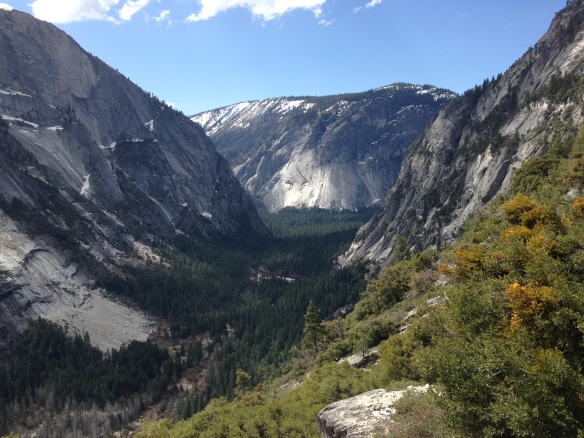
Tenaya Lake and Beyond!

Day 3: Tenaya Lake & Snow Creek Cabin (March 29, 2013)

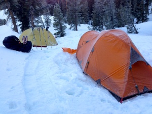
Frosty TentsThe morning was very cold with a thick layer of frost covering the tents, so we didn’t waste time packing up and getting on our way. Once we got out of the small valley we camped in the temperature warmed up significantly. The sun was out and a few clouds floated overhead.

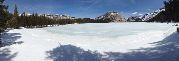
The four miles between camp and Tenaya Lake were mostly down hill and went by quickly. We arrived at Tenaya about noon. The lake was frozen over with a layer of blue ice. We could see ski tracks crisscrossing the surface.

Ice covered Tenaya Lake

Ice covered Tenaya Lake

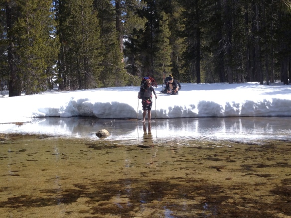
From Tenaya we were going to follow Tioga Pass towards Snow Creek cabin. Before we could continue down the road, we first had to cross the wide outlet of Tenaya Lake and there was no bridge… We found a section that was fairly shallow and would let us cross to a snow free patch of river bank.

Tenaya outlet crossing

Stepping out of the boots onto the cold snow was accompanied by a few yelps of shock. The snow bank held us about a foot and a half above the water and the first step down was taken with visions of the snow breaking away under foot flashing through my head. The water felt surprisingly warm compared to the snow moments before, but after a few steps the cold crept in and my toes began to tingle, each step getting a little shakier as the cold water numbed my feet. Back on the dry river bank we stopped for lunch and let our feet dry and warm up in the sun. The air temperature was quite pleasant.

Making our way down Tioga Pass

Making our way down Tioga Pass

After lunch we started our way down Tioga Pass towards the Tuolumne Meadows Trail. We were getting the full force of the afternoon sun as we made our way down the road. The sun had made the snow quite soft which made for slow going with the snow shoes. Hiking was hot and slow, but offered some spectacular views of Clouds Rest.

Clouds Rest's granite face

Clouds Rest’s granite face from Tioga Pass

Once we reached Tuolumne Meadows Trail, we left the road and started descending towards Snow Creek Cabin. The trail was marked by license plates attached to trees high above snow line. We lost the trail markers as we descended from the ridge where we found the stream that the cabin was supposed to be by.

The exact location of the cabin is not clearly marked on maps and does not appear on the Tom Harrison map that I had. So we were following GPS coordinates that we found online along with a vague description of the location of the cabin. We found the intersection of the Tenaya Lake and Tuolumne Meadows trails. From there is was a matter of fanning out and playing a game of hide-and-seek with a cabin. We wondered the woods for 15 to 20 minutes before I spotted the cabin peaking out between the trees!

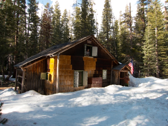
Snow Creek Cabin

Snow Creek Cabin

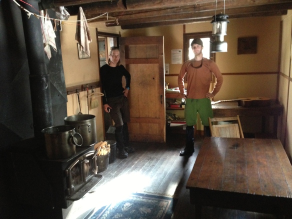
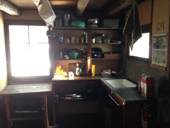
The cabin was far greater than any of us imagined! It was two floors complete with a wood stove in the living area, a kitchen (no plumbing or electricity, but it did have a propane stove!), three bedrooms, outhouse, and an ample supply of dry wood! There were cards, board games, books, dishes, and even a guitar! We were the only ones there, so we got a fire going and enjoyed a warm evening in a backcountry cabin.

Snow Creek Cabin - Living Area

Living area

Kitchen

Kitchen

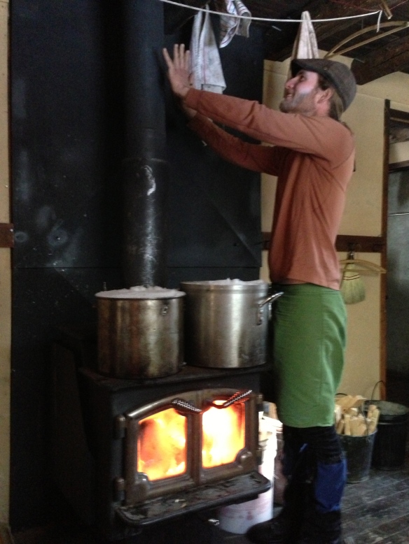
Warming up by the fire

Warming up by the fire

Day 4: Descending Snow Creek Trail (March 30, 2013)

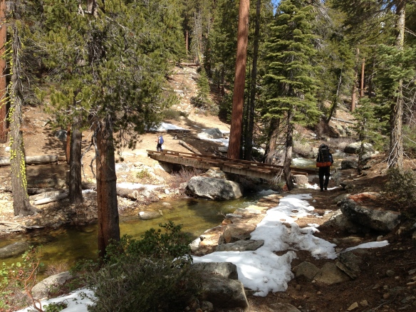
Bridge over Snow Creek

The next morning we closed up the cabin and started our way down Snow Creek Trail to the valley floor. This trail descended gradually for a couple of miles before we started down the 108 switchbacks to the valley floor. The descent was steep and offered great views of the valley below, but I was very glad we didn’t climb this route our first day out.

It wasn’t long before we were back at the car and on the road back to the Bay Area. The end of amazing trips is always sad, but it was a great feeling to have conquered Clouds Rest in the snow!

——

Don’t miss out on the first half of this trip!

For more photos check out the album on Flickr!

Descending Snow Creek

Descending Snow Creek

Winter Wonder Land

Be sure to read about the first half of this trip! Snowshoeing in Yosemite, Days 1 & 2

Its Snowing! (Sunday, March 25)

Snow starting to accumulate on the tent.

I awoke early Sunday morning to the sound of sleet hitting the tent. It was still dark, so I stayed in my sleeping bag for a while wondering how much had fallen through the night. The sides of the tent weren’t sagging in, so I figured it couldn’t be much, if any. As the sky got brighter, I poked my head out the door. No snow yet, but it was definitely starting to come down. By the time we were up and ready to do some hiking, there was a nice layer beginning to form on the tent and the snow flakes were starting to get bigger. This was the first time I had seen it snowing since I moved to California 3 years ago… Exciting!

Since our camp was sheltered by the trees, we were a bit surprised to find that 2-3 inches had already fallen when we got to the clearing by the stream to fill our bottles for the day. The snow was light and fluffy, and the air was still and quiet.

Snow falling on the Merced River (Photo Credit: Paul)

Trees left bare from a recent forest fire.

We had decided that we would follow the Merced River Trail a few miles before having lunch and returning to camp at LYV. The trail was marked with old tracks that were quickly being covered by the new snowfall. Our path was also frequently blocked by fresh tree fall. As we continued, we passed through a section that looked to be recovering from a recent forest fire. The bare trees looming in the falling snow carried a much different mood than the rest of the trails we had been on. Fire damage in combination with the wind storm that moved through CA last fall was probably responsible for all the downed trees. The trail maintenance groups will definitely be busy this spring.

The trail continued following the river through the valley with very little elevation gain. As the valley narrowed we got some to see some beautiful scenery as the snow fell silently on the river.

Looking up river in the snow

Me, making my way over a very slick tree crossing. (Photo credit: Paul)

Continuing up the trail, we came across a couple tricky stream crossings. The snow had made the trees slick and hid many of the holes between rocks and logs making navigating the crossings extra tricky.

After straddling a few trees, we arrived at a perfect swimming hole (were it a few degrees warmer of course). From here we climbed along a large water slide that looked like a perfect launch point for the swimming hole. A short while later we came across a second swimming hole with the same water slide entry. During the summer these probably get plenty of attention, but on this day, we had them all to ourselves.

Water slide into the lower swimming hole

Upper swimming hole

At this point we made our way up a short series of switchbacks heading further up the valley. We could feel the temperature dropping and the snow and wind began to pick up. It was now about noon, so we decided it was time to think about lunch. A short ways up the trail, Paul found a small cave that we took shelter in and enjoyed lunch while watching the powder fall. It had become very humid, and our rain gear was becoming damp on the inside, so it was nice to get out of the weather and air out the jackets a bit.

Looking out of the lunch cave. (Photo Credit: Paul)

After having some lunch, we decided it was probably a good time to start heading back to camp. We estimated we had gone about 4 miles, and the return trip would be slower with the deeper snow.

As we loaded up to head back, we had to shake off our rain jackets, which had iced over during the break. It was definitely getting colder. The snow had also picked up and, now approaching a foot deep, nearly covered the tracks we had made only 30 minutes earlier. Descending the switchbacks became significantly more tricky with the added snow. The fresh powder hid a shallow stream flowing between many large loose rocks. It was slow going.

Where did the tent go!?!

As we neared camp, the snow had pilled up to easily a foot!

Making our way through the trees, I was looking out for the bright orange rain fly of the tent. I knew we should be close, but I wasn’t seeing it. Walking into camp, we found the tent buried under several inches of snow. It was a very good camouflage!

After digging out, we took shelter in the tent for a while until the snow let up. It was getting close to 6pm and I was starving. I went for a second round of tortellini. I had brought olive oil with to use as a sauce, but this proved difficult as it had turned to a solid in the cold! (Once back in Oakland, I looked up the melting point of olive oil… 21F! brrrr!!!)

Hiking Out (Monday, March 26)

Snow cover from the night.

Shortly before dawn we awoke in a very humid tent. Everything had a layer of moisture on it and the ceiling of the tent had started dripping on us. It had continued to snow through the night and deposited another few inches on the tent. This blocked our ventilation and turned our cozy tent into a humidity chamber. We knocked off what snow we could from the inside and unzipped the door since it had now stopped snowing. An hour or so later, the sun started coming up and we emerged from a snow covered tent under a bright blue sky!

Half Dome showing off a new coat of snow

One last look at the watering hole before heading into the valley

After a quick breakfast, we packed up camp and started our way back down the valley. All the previous tracks had been covered, and we were breaking trail through about 15 inches of powder. It was slow going, and we starting making guesses as to how far we would get before encountering day hikers.

As the sun climbed higher in the sky, the trees began dropping the piles of snow perched on their branches. I seemed to be a more favorable target than Paul as I ended up with a much larger amount of snow down my neck than he did. The trail began to descend towards the top of Nevada falls at the intersection of the JMT and the Upper Mist trails. It wasn’t long after this intersection that we decided to take off the snowshoes.

Nevada Falls

When we reached the top of Nevada falls we came upon the first group of day hikers. There were around 10 of them and they looked a bit surprised to see two people coming down out of the high country. The snow was still about 12 inches deep, and they were significantly under prepared for the conditions. With one backpack between the 10 of them, only a few water bottles, soggy tennis shoes, and two of them in shorts and t-shirts, they asked if they were heading the right way for Half Dome. They were, but we told them that the cables were down for the season and that the snow only gets deeper from there with no tracks leading up the Half Dome trail from LYV. They were undeterred.

Looking at Glacier Point from near the top of Nevada Falls

As the elevation decreased, the snow turned from powder to packed powder from day hiker traffic to a heavy wet layer on a soggy trail. We continued descending until we reached the top of Vernal Falls where we stopped for lunch. Relaxing at the falls overlook, Paul made the observation that this was probably the only time of year that you could be alone at this spot. This was probably true. My previous visit to this spot was in October 2009 and I was in the company of 20 – 30 others taking turns standing at the rail for a quick photo. The solitude was nice and being able to enjoy the moment rather than being pushed aside by someone else wanting a picture was even better.

Glacier Point being a little camera shy in the clouds

After lunch, we continued down. The trees were now dripping under the warmth of the sun, day hikers were a regular sight and we soon joined with the portion of the trail that was paved. After many, many switchbacks, we finally reached the valley floor. My knees were happy to be traveling on flat ground again, but my feet were looking forward to getting rid of the pack and having a seat at the car. A long mile later we had arrived!

We loaded up the car and changed into some fresh clothes (Except for Paul’s shoes… he had forgotten to bring road shoes and was stuck with some soggy boots… bummer!). But a trip to the Valley would not be complete without taking a dip in the river! Unfortunately, Paul could not be convinced, but I made a quick, and chilly dip in the river before hitting the road back home! It was the perfect end to a great trip!

Many more photos can be found on Flickr, or in Paul’s Facebook album

Additional resources:

Topo Map

Eastern Sierra Avalanche Center

Clouds Rest Summit Post

Trip Report (These guys ran up Clouds Rest in the snow!)
Judgment Calls

Snow has been surprisingly absent from this years winter. But a storm finally brought about 4 feet to Yosemite’s high country. This of course meant it was time to hit the trails for some snowshoeing!

The recent storm had dropped a significant amount of snow in a short period of time, and because of the mild winter, this created unusually dangerous avalanche conditions. Because of this, we decided on a few route variations in case the conditions didn’t improve by the start of our trip. The idea was to do a loop starting at Happy Isles in Yosemite Valley, head to Tenaya Lake (crossing Clouds Rest, 9,931 ft), then loop back to the valley via Snow Creek.

Happy Isles to Little Yosemite Valley (Friday, March 23)

We arrived at the ranger station shortly after 9AM to get our wilderness permit and get some info on trail conditions and weather from the rangers. While the avalanche danger had decreased significantly, more weather was approaching quickly. They were expecting 3-5 inches above 6,000ft on Sunday and another 3-5 Sunday night with the snow line dropping to 4,000ft. Then more rain/snow on Tuesday. As we were talking with the rangers, a guy came in saying he had just come from near the top of Nevada Falls where he encountered foot-deep snow worthy of snowshoes. With this new info we got our permits for the loop with the idea that we would make a final decision on our climb up to Little Yosemite Valley (LYV).

Permit in hand, we were on the trail! Since it was winter, a portion of the Mist trail was closed, diverting us to the John Muir Trail. This added about a mile, making the trip to LYV a little over 5 miles with about 2,200 ft of gain.

The trail was steep, and we quickly climbed up out of the valley past Vernal and Nevada Falls. We passed a several people along the trail, but there were significantly fewer people than my last time on this trail, when I was making the trip up Half Dome. The trail was mostly snow-free with the exception of a few shaded switchbacks.

Looking at Nevada Falls from Clark Point on the JMT

The switchbacks going up the side of Nevada Falls were very steep, but offered a great view of the valley disappearing below us. As we continued up, we came across a portion of the switchbacks that had turned into a series of mini water falls as the melting snow came rushing down into the valley. I was definitely glad to be wearing my boots rather than the tennis shoes worn by most of the day hikers we encountered.

Paul snapping some pics of the valley below.

At this point we began wondering just how far the guy in the ranger station had made it before tuning around. We were now almost 4 miles in, at the top of Nevada Falls, and had not encountered any snow that would have warranted the use of our snowshoes. How far had this guy really gone? And what time did he start in order to get to the ranger station at 9AM!

Passing the top of Nevada falls marked the end of the significant climbing for the day. The trail flattened out and rolled along another mile to LYV where we would set up camp for the night. This is where the snow began to get deeper and form a consistent cover over the trail. However, there were plenty of tracks leading the way, making travel without snowshoes easy… This continued all the way to LYV where we encountered two other pairs of people that we would be sharing the campground with that night.

Home Sweet Home

We arrived at camp around 3PM, pitched the tent, then found our way to the nearby stream to fill our bottles and relax a bit before cooking some dinner. This also gave us time to discuss our plans over the next couple days.

We discovered that I had access to data thanks to AT&T’s wonderful coverage (it was a no-go for Paul’s poor Sprint phone…), so we were able to check in on the weather. Sure enough, there was some, possibly significant, snow coming in on Sunday. Since both of us are pretty new to winter backpacking with significant amounts of snow, we decided it would be in our best interest to stay in LYV for the storm. Our revised plans were now to base-camp it at LYV and climb Clouds Rest with day packs the following day. We would ride out the storm at LYV, then head back into the valley on Monday.

After a nice dinner of three-cheese tortellini, it was off to bed!

Little Yosemite Valley to Clouds Rest (Saturday, March 24)

We got on the trail a little after 7:30AM, a tad later than planned. This wasn’t too big a deal since we had decided to go with day packs allowing us to travel at a much quicker pace. It was 7 miles to the summit, with about 3,800 ft of elevation gain. The trail was all up and it didn’t take long for me to be happy I wasn’t hauling a full pack!.

One of the many bear tracks on the trail.

Being on a south facing slope kept the snow depth down, but as we climbed the snow slowly got deeper. We had been warned by the rangers that the bears had been very active this season, but we saw no evidence of the furry creatures around the campground. This was not the case on the trail… We came across many sets of bear tracks criss-crossing and following the trail. We even came across fresh tracks on the way back down!

Continuing up the trail, the snow became a constant blanket under our feet. And after separating from the Half Dome trail we were given our first views of the surrounding area.

Paul putting first tracks in on our way to Clouds Rest. No need for snowshoes yet!

Half Dome peaking out from between the trees

About a mile from the summit we crossed over a ridge onto a southeast facing slope. The snow depth jumped up to about 3 feet and the trail was no longer visible. We made our way across the snow through the trees gradually climbing up to the ridge that led to the summit. At the top of the ridge, the wind picked up significantly and we go our first look at the granite slope on the back side of Clouds Rest. We could see sections where the snow had begun letting loose allowing gravity to cary it down into the valley below.

The last push to the summit was very steep. As I began making my way up, but it became clear that it was too steep for the snowshoes as I began sliding backwards with each step. This was definitely unfavorable as the snow was sloped just right to slide me right down the cliff into the valley. With the snowshoes off, I began post-holeing up the slope. This got me a bit further, but I ran into a section of thin snow sitting on a nice icy crust that offered little in the way of traction. With the wind gusting around 30 mph I looked down the slope on my left, then back at Paul who was having a bit of trouble dealing with the trail conditions.

About 100 ft bellow the summit I turned around and took a seat in the snow. After a brief chat with Paul, we decided the snow conditions just weren’t right for us to continue. It was about 12:30PM and the snow was to soft to provide the right traction… Had we arrived an hour earlier it may have been a different story, but at that moment we decided to turn back. But not before snapping a few pictures of course!

Half Dome from Clouds Rest

Yosemite Valley from Clouds Rest (Photo Credit: Paul)

Back in the cover of the trees, we again strapped on the snowshoes and headed back towards camp. With 7 miles of descending ahead of us, we took our time and enjoyed a few extra sights along the way.

Checking out Half Dome from atop a snow drift. (Photo Credit: Paul)

We got back to camp at about 5:30PM. A significant amount of snow had melted during the day, and the other camp inhabitants had left. We refilled our water and made dinner… tonight was tuna pasta with alfredo sauce, yummy. As we filled our bellies with a much deserved meal, we reflected on our summit trip, and still felt that we had made the right call in backing off. And after checking the weather, it looked to have been the right call to base camp it at LYV rather than continue on the loop as the weather was beginning to move in. Unsure of what tomorrow would bring, we buttoned up camp, prepped the tent for the possibility of significant snow, and went to bed.

More photos can be found on Flickr

Continue with Days 3 & 4!

Leavitt Meadows to Long Lakes, September 16-18, 2011

After far to much time nestled in the crowded metropolis of the Bay Area, it was time to escape to the warming embrace of the wilderness. This trip was put together by my good friend Paul. The initial destination was to be somewhere within Yosemite National Park. After studying the red tape that is the permit system, we decided to set our sites on the surrounding national forests. Leavitt Meadows was suggested to Paul by a friend from his days as a Corn Husker.

The Route:

Starting at the Leavitt Meadows trailhead on the east side of Sonora Pass on CA highway 108, the trail follows the West Walker River south to Tower Lake.

Friday, September 16th:

Having to first survive the day at the lab, Paul, Herman and I met up at my place in the late afternoon to do a quick pack shakedown and add my food supply to Paul’s bear canister. Then we took a short ride across town to pick up Ulrike, and we were on our way! After minimal traffic and a pit stop at In’n Out, we rolled into the trailhead campground at about 11pm. The air was brisk, and we called it a night after a few star gazing moments.

Saturday, September 17th:

Leavitt Meadows

The goal of this trip was to get out of civilization and have a relaxing trip to the woods. With this as the mindset, we got up shortly after sunrise with out the aid of the incessant scream of an alarm. The morning air was cool and refreshing, maybe about 40F, but warmed quickly as the sun peeked over the ridge line. After a quick breakfast and filling out the necessary wilderness permits at the trail head, we were on our way!

Brrrr, that water is cold!!! Not quite August in Nebraska...

As we continued our stroll, the trail slowly climbed along the base of a ridge line from the trail head at about 6,500ft and passed several beautiful mountain lakes and eventually bringing us to the bank of the West Walker River. After following the river for several miles, our stomachs began to beckon for something a little more substantial than Cliff bars and GORP. About that time we also happened across a side trail to Hidden Lake. That sounded like a great place to have lunch, but after a knee deep river crossing that almost got the best of Paul, we decided the river bank would be as nice a picnic area as any.

Llama!

After lunch and another chilly river crossing, we continued on our way to Fremont Lake. The trail continued to follow the river which continually changed from narrow fast moving rapids to wide still pools. The trail was well worn, and was littered with evidence of heavy use by four-legged steeds (it was a horse trail after all), but as we walked we turned the corner into a pack animal of a different breed! As we stepped aside, one of the hikers that the llamas were leading down the trail (cause you know its only an illusion orchestrated by the animals that people are in control) asked us where we were heading. We said, “Oh, just heading up to Fremont Lake.” Without hesitation, the hiker responded with what sounded like a scoff, “Hm, Good luck…” After they passed we looked at each other a bit surprised… we were under the impression that we were only about a mile from the lake!

After double checking the map, we decided that they must not have meant that we would be lucky to get there. Sure enough, after a shot time longer we reached Fremont Lake.

Our first view of Fremont Lake

Hermann, Ulrika and Paul take in the sights

While the trail was pretty sparsely populated, we immediately noticed the sounds of people drifting across the lake. After lounging for a bit, we decided that it was still early, so we would continue on down the trail rather than setting up camp here. So we set off towards Long Lakes.

This stretch of trail brought us away from the river and climbed up the ridge towards Long Lakes. As the light began to fad, we came to Lower Long Lake (~8,600ft) and decided that it was time to call it a day and set up camp. There were several flat grassy areas nestled in the rocks around the lake, so we took our choice, set up camp and as the sun began to set and the temperature began to drop, we busted out the hot drinks!

Camp at Lower Long Lake

91 octane!

A little Irish coffee...

A little spiced cider...

Sunday, September 18th:

Paul takes in the morning sights

The morning brought frosty tents and crisp air. We decided over breakfast that we would continue along the trail to complete a loop around Upper and Lower Long Lakes. The previous day had brought us about half way around, so the loop wouldn’t add any milage, but would allow us to see a few miles of new trail rather than back tracking the whole day.

As we neared the trail intersection that would start us back to the car, we paused to shed some layers and much on some bars and saw two older hikers heading by. They had some space between them and the lead hiker passed through the trail intersection without hesitation. When the second came to the intersection moments later we heard him call out, “Hey! Do you have the map!” With a response of, “Yea!” they continued on down the trail without consulting the map…

Ulrike taking in the beauty of the American country side in person

We picked up the trail that would lead us back to the car and it descended down the valley meeting up with the river we had followed for much of the day before. It was much smaller now, as we were several miles closer to its beginning. As we followed the river through the valley it slowly began to grow. We followed it to a field where Ulrike noted that “this is the picturesque American landscape.” Or at least closely resembling the photos of the American frontier she knows from Germany. As we continued through the field we made our last river crossing. This time Paul, having

Paul and Hermann fording the river... No oxen were lost, though Paul nearly got pneumonia.

learned from his close encounter with a cold and unexpected bath, as well as the wisdom of Hermann, had acquired a walking stick to aid in his journey through the depths. This crossing went a lot smoother than the previous ones.

Shortly after we leaving the field we came across a man leaning against a downed tree fixing some gatorade. He had been out for 6 days, and said we were the first people he had seen in 5 days! That’s a long time to go without talking to someone, definitely longer than I’ve ever gone. Yet what my mind was more focused on than this man’s recent lack of human contact, was why had he not seen the older hiker pair who were not far ahead of us…

Giddy-up!

As we continued on, the trail briefly ventured away from the river to make a rocky descent further into the valley. While on our descent, we had to step aside to make room for a few noble steeds complete with cowboy. When they passed us again on their way out we attempted to thumb-a-ride, but alas, they were not going where we needed to go.

Further down the trail, we decided that the cool water of a lake would be a nice finishing touch to a great weekend adventure (not to mention clean us up a little before the long drive back). We paused for a while for a dip in Roosevelt lake. The water was cool and refreshing. As we sat on a rock,drying off before heading on, we noticed a bunch of crayfish wandering around the rocks in the lake. We figure our quick dip must have stirred up a good afternoon snack for the little guys.

Sad to see the trip coming to an end, we took in a few last sights before arriving back at the car. It was a perfect weekend for a quick break from reality!

The crew takes a final look before hiking out to the car

Paul showing of his packing skills. Great job planning this trip dude!

More photos can be found on Flickr

Technology on the Trail:

On this trip I did a little technological experiment. Rather than using my usual point-and-shoot camera, I took all my pictures using my iPhone in order to capture the GPS tags that locate the pics with the places feature. Here is the result…

Photo GPS tags in iPhoto