Day 1: South Fork Trailhead to Dry Lake
Day 2: Summit Day – Dry Lake to Red Rock Flat
Day 2 started early. My alarm woke me at the lovely hour of 3AM. I woke surprisingly quickly. It may have been due to the 6PM bed time the night before, or maybe the adrenaline of knowing it was time to climb the mountain. The weather forecast had said there would be a 30% chance of snow this day, and I was worried about opening the tent to find ourselves socked in by clouds. With no idea how far the tracks continued up the trail, I feared the idea of having to route find with limited visibility… this would most likely have put an end to our summit dreams.

Summit bound under the new moon
I opened the tent to find it darker than dark outside as we were going to be under a new moon for our pre-dawn hike. The air was still and there were no snow flakes falling from the sky above. Looking up, I saw a sky that was crystal clear and full of tiny points of light (many more than visible from the sky of the Bay Area). This was definitely a relief.
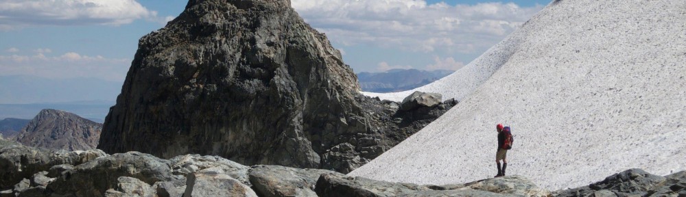
After packing up camp and strapping on our snow shoes, we headed up the trail towards Mineshaft Saddle. We got on the trail by 4AM, and with the saddle about 2 miles away, we figured we would get there by sunrise.
As we hiked, it became clear that we were following only one set of tracks… those belonging to our trail blog friend who had turned back only 2 days earlier. I was happy to have a clear trail in front of me.
As we approached the saddle, a dim glow appeared over the ridge. I was happy to see morning arrive, and the saddle provided the perfect vantage point to watch the new day begin!

Day break from just above Mineshaft Saddle on Thanksgiving

Snow drifts slowly covering the trail
On the saddle, our trail intersected with Fish Creek Trail. There were no tracks coming up that trail, and the ones we were following continued up the mountain. While the air was still, the trail showed evidence that we had crossed over to the windy side of the mountain. The tracks had begun to be filled by drift snow traveling across the slopes, and the snow was consistently over a foot deep.
Continuing on, the slops continued to get steeper while the tracks we were following continued to disappear. As we followed the ever diminishing trail, a few gentle breezes started passing through. They were gentle and surprisingly warm… I enjoyed the feel of the warm air on my face, but hoped the winds would not pick up or bring the snow that had been forecast.

Trails don't last long on the snowy slopes

Making first tracks as we pass the plane wreckage
As we approached the beginning of the switchbacks, we came up to the site of the 1953 plane crash. The wreck had been mostly covered, but there were a few pieces still visible through the snow. This was also the point where our trail disappeared into the powder. We had reach the point at which our blogger had turned back. I could see the switchbacks weaving their way up the slope and began wondering how far we would get. It was still fairly easy to kick steps in the snow with my snowshoes, but for how long would this be true? There is of course only one way to find out, and with a beautiful, clear sky above us, we continued onward and upward!

The sun greeting us as we reach the top of the switchbacks
The switchbacks presented quite a challenge. While the trail was easy to follow through the trees, marked by evidence of trail maintenance, gaining about 1,000 feet in such a short distance is never easy… especially when shuffling through over a foot of snow. Our efforts were well rewarded. After no fewer than 8 switchbacks, we crested the ridge into the warmth of the ever rising sun to see the valley below to the east and a low lying blanket of clouds to the west. It was now approaching noon and we were within 2 miles of the summit. We estimated that we were about 30 min behind our expected pace, but after getting a quick lunch and checking the map, we continued on to the summit.

Summit this way!
As we pushed along the last bit of trail to the summit, I could feel the air getting thinner while my feet seemed to get heavier. Coming around the mountain allowed us to see the extent of the trail. It looked like a white carpet gradually sloping upward along the ridge. I knew somewhere out there was the trail junction that would take us up to the summit. Now that it was in sight, it seemed so close, but as my legs grew more tired, and my lungs had to work ever harder to get oxygen from thinning air, it seemed so far away. Then I saw it… the trail sign pointing towards the summit!
It was now almost 1:30PM and we had been hiking for over 9 hours. We dropped our packs to make a quick detour to the summit… half mile out, half mile back. We had made it… and what a way to spend Thanksgiving!

San Jacinto Peak holding back the clouds

We could see Dry Lake where our day began so long ago

The summit trail stretches out along the ridge
After celebrating a bit on the summit (11,501 feet), and enjoying the feeling of having a whole mountain to ourselves, we turned back and began our descent to Red Rock Flat. It was now 2PM and we still had almost 5 miles to go to reach the camp. While it was all down hill, we were feeling the effects of the sun, the altitude, and the hours of hiking and I wanted to be sure to get across the last steep snow field before the sun dropped to far and the snow crusted over.

Summit trail junction
We hoisted our packs and began down the trail. Since we were above tree line, we no longer had the cut branches of trail maintenance that I had grown a custom to following. It was up to my topo map skills to get us back to tree line (though I had a bit of help from the GPS of my iPone, which definitely came in handy). Descending was a nice change of pace, and the trail kept us on the sunny side of the ridge. Looking back we could see the trail we had been following stretching back along the mountain for miles.
Crossing the last snow field and ducking back into the trees, we found ourselves less than a mile out of camp with a perfect view of the sun set. The colors were spectacular, and provided the perfect back drop for the cloud filled valley stretched out before us. We stopped to grab our headlamps and watch the day slip away.

Sun ducking below a sea of clouds

The day fades through the trees
With the last of the light fading, we found our way into camp. We were on top of a ridge at about 10,000 feet, and as the sun disappeared, the wind picked up, the temperature dropped rapidly and what remained of my water started to freeze. We layered up, and quickly got the tent set up. My excitement for having a nice hot bowl of tuna rice was overshadowed by my desire to get into my fluffy down bag. Dinner turned into several handfuls of trail mix, jerky, cheese, and a few bites of summer sausage. Once warm, Paul fired up a stove to melt a bit of water to get us through the night, and I piled up snow to help protect the tent from the wind gusting over the ridge.
With the sun gone, and another night of new moon, it was pitch black out. But while building our snow wall, I noticed a strange orange glow on the horizon. I knew it couldn’t be the sun, that had set nearly an hour ago. Looking out into the dark I saw thousands of glowing points. The clouds had cleared, and the lights of San Bernardino were now illuminating the sky. As isolated as the mountain had felt all day, it was hard to believe the city was so close.
Crawling back into the tent, I could feel the toll that the day had taken on me. It had been a long day, and my body was ready to retire. It took us 13 hours to get from Dry Lake to Red Rock Flat, and I felt it. I was asleep moments after climbing into my sleeping bag and didn’t stir until the sun came up the next day…
Day 3: Red Rock Flat to South Fork Trailhead
More photos can be found on Flickr

Glad I stopped by your site. This reads like a novel in first-person. And the photos are breathtaking. I’ll be back.
Pingback: 1820 Glencrest « AFFINITIES…