Day 1: South Fork Trailhead to Dry Lake
Day 2: Dry Lake to Red Rock Flat
Day 3: Red Rock Flat to South Fork Trailhead
When I awoke it was already bright. Rolling over to find my phone and check the time took a bit more effort than it had the day before. All of my muscles were letting me know that the previous day had been a big one. It was about 9:30AM, the wind was blowing and I couldn’t tell if the snow hitting the tent was fresh falling or just being blow from its resting place on the hillside. Between the wind and my stiff muscles, I wasn’t in a hurry to get up. There was no need to hurry either. There was no big summit or target to get to today. The idea was to just wander out along the ridge and turn around at some point to make camp at Dollar Lake.
I climbed out of the tent to a clear sky, but it was much cooler and windier than the day before. Paul and I found shelter behind a large log to make breakfast and decide where we were going to hike to. Since both of us were feeling the effects of a long summit day, we decided to take a nice easy hike down to Dollar Lake. It was only 1.5 miles away and about 800 feet lower in elevation so it should be warmer and more sheltered from the wind.

The trail can barely be made out under the drift snow
It was 11AM by the time we had camp packed up and were ready to take off down the mountain. The start of the trail was in the shadow of the ridge and had a strong wind blowing up the slope… and with out previous tracks we again found ourselves post-holing through knee-deep snow. Today, however, this didn’t last long. The snow level decreased and the temperature increased quickly as we descended.

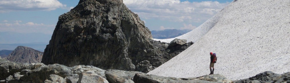
Continuing the descent as the snow cover thins
Once we crossed into the sun, the snow depth had decreased significantly and we quickly came to the trail intersection that would take us to Dollar Lake. We had traveled quickly and it wasn’t even noon. Looking down the Dollar Lake trail, we noticed that we would most likely be building camp in the shade. And without a lot of side hiking opportunities or desire, this looked like a cold way to spend an afternoon. After a little discussion, we decided to go ahead and return to the car which would give us two days back in Berkeley to clean gear and recover before having to return to reality and the lab… so we continued downward.
As we descended, the snow cover continued to decrease and we stopped to take off the snowshoes. That made the pack a bit heavier, and I stumbled over my first few steps while my body remembered what it was like to walk without these large flat things attached to my feet. But after a few steps I had learned to walk again, and our pace picked up significantly. It was yet another beautiful day for a hike!

Looking back at the summit of San Gorgonio on the descent.
About halfway down the trail, we rounded a corner and came up on a set of foot prints in what remained of the snow. We were no longer going to be putting in first tracks. Though we had yet to find a person to go with those tracks, I was suddenly reminded that we were in fact on a fairly well traveled trail and no longer felt so removed from civilization. After a bit further, we came up on Richard. He was a volunteer park ranger (as many rangers in CA are now due to budget cuts) out on a day hike towards Dollar Lake. He told us stories of people he runs into with tennis shoes and a single bottle of water with the idea that they would make it to the summit and back in the snow. We had a few laughs about this, then showed him our permit and continued on. A little while later I hear Paul laugh behind me… I look back and he says, “You know what I just realized? We just met Ranger Rick!” HA!

Paul fills his bottles
Meeting up with the South Fork trail that our journey began on, we stopped at a stream crossing to fill our bottles. This was much faster than melting snow for water… MUCH FASTER! I filled and emptied my bottle a few times and watched as the water rushed in to fill it with a strange feeling of amazement in how quickly the stream would fill it. Here we met two guys that were heading up to the summit via Dollar Lake taking the reverse trip we had just done. They didn’t have snowshoes, but seemed unconcerned when we told them the snow conditions we had just stomped through.
After a few bars and several gulps of water we continued down to the car passing about a half dozen day hikers with various degrees of preparation. We noticed what Ranger Rick had pointed out about shoes as we passed about 4 people in sneakers and tees. Shortly after leaving the wilderness area, we met two more rangers that were heading to the summit following the same path we had just taken. They were happy to get a snow report, and even happier to know that they wouldn’t be breaking trail on the way…

Victory Beer!
By 2PM we had made it back to the car! My body was thrilled to put down my pack and my feet happy to get out of my boots. Siting on the bumper, I thought back to the many trips I took during my time with the outdoor program in college, and remembered a few words of wisdom, “The trip’s not over until you’re drinking beers at the car.” The summit day on San Gorgonio was proof to that. The summit had been reached the previous day, but there was still much to push through to make it a successful summit trip. Now that we were back at the car, it was time for that victory beer!

Screen shot of the map app
Technology on the Trail
Prior to coming on this trip I had found a trails app for my iPhone. It had high reviews primarily because it downloaded USGS maps to the phone so that it can be used without access to cell or data service. It also has other cool features such as GPS and compass as well as the ability to tag locations and shade slopes based on time of day. Since there is only so much that can be achieved by playing with a map app in my room, I decided this would be a good trip to try it out on. (We brought a real map and compass along just incase…)
The app worked great! The GPS was able to pinpoint our location to within 8 feet of where we actually were. Where its benefits were most appreciated though, were above tree line. Following the trail within the cover of trees was not very challenging. For the most part we just followed the widest path between trees, and confirmed it was the trail by looking for signs of trail maintenance (most notably branches and logs cut by saws). But above tree line we had to rely on stacks of rocks that were, for the most part, covered in snow. With the help of GPS, staying on the trail above tree line was trivial.

Pack equipped with solar charger
However, since I also use my phone as my primary camera to get the GPS tags on all the photos I take, there became an issue with battery life. How would I keep the notoriously short lived iPhone battery charged for several days while routinely using the GPS? For that I turned to the sun. I picked up a solar charger from Goal Zero and strapped it to the top of my pack. This kept my phone charged and ready to go for the duration of the trip!
More photos can be found on Flickr
