Thanksgiving provides a great opportunity to take a trip someplace a bit farther than can be done in a weekend. In the beginning of planning this Thanksgiving trip, San Gorgonio became the target because it is the tallest mountain in Southern California at 11,500 ft. Initially, the weather looked like it would either be in the 50’s or on the leading edge of the winter snowfall. The route we decided on was to summit via the South Fork Trail.
As the trip date closed in, it became clear that we were gonna encounter a bit more snow than originally expected. Then, the day before leaving, someone posted on the trail blog that they had to turn back and recommended crampons for climbing the steep switchbacks. While we weren’t sure what this meant for our summit dreams, it didn’t deter us…

San Gorgonio Wilderness Boundary
Day 1: South Fork Trail to Dry Lake
The South Fork Trail head starts at about 6,200 ft and there was snow on the trail from the start. It was patchy at first, but didn’t take long to become at steady layer on the trail. The trail was well traveled with several sets of tracks leading the way.
About two miles in we passed the trail to Poopout Hill and crossed into the San Gorgonio Wilderness. From there the snow began to deepen and the trail began to pick up altitude. As we continued we arrived at the trail split for Dry Lake. The footprints followed the Dry Lake trail, while we got a look at the

Dollar Lake trail free of tracks
trackless trail coming from Dollar Lake that we would be returning on in a few days. This left me wondering how far the tracks continued along this trail. Did they go all the way to the top, or did they stop at the switchbacks where our guy from the trail blog had to turn back? The answer to this question would have to wait until tomorrow when we pushed for the summit. Until then, we continued to Dry Lake.
Getting to Dry Lake required several stream crossings. Some were small, and others were a bit tricky with the snow covering some boot sized gaps between logs. After some graceful steps (and plenty of balancing help from the hiking poles), the streams were crossed, and Dry Lake was a few steps closer…

Paul navigating the snowing crossing... August in Nebraska?

Snowy Stream
After crossing the streams, the tracks thinned and the trial climbed to the top of a ridge. As we crested the ridge, the summit became visible through the trees, and with the sun behind the mountains, it had an almost mystic glow in the sky. I could feel the excitement for the summit day growing…

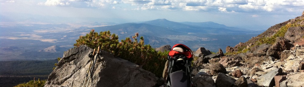
San Gorgonio appears through the trees

San Gorgonio (left) and Jepson Peak (right)

Ice covered Dry Lake
We arrived at Dry Lake to find it frozen over. The 3,000 ft we had gained since leaving the trailhead had brought cooler temperatures (mid 40’s in the sun) and deeper snow at our first camp at 9,000 ft. We put on our snow shoes in order to leave the trail in search of a place to pitch our tent. The snow was a nice powder and about a foot deep.
As the sun started to dip behind the ridge, we got camp set up and made dinner. With the frozen lake and a thick layer of snow hiding any flowing water, we filled our water bottles by melting snow in preparation for the big summit day coming quickly. With few daylight hours, we decided to get up at 3AM to pack up camp and get on the trail by 4AM. It would be 5 steep miles to the summit at 11,500 ft, with 5 more miles to camp. Hoping to average 1mph, this would get us to camp before sunset.

Camp at Dry Lake
With food in our bellies, water in our bottles, and a plan for the summit, we called it a day and the late hour of 6PM…
More photos can be found Flickr

Looked like an amazing Thanksgiving trip! Thanks for sharing the photos.