Fishing in the High Country

Minarets Sunrise (Photo Credit: Paul)

Day 4: Ediza Lake to Garnet Lake (August 25, 2012)

I woke up at 4am to Paul’s alarm. He moved just enough to shut it off and I wondered if he would have the motivation to get up and hike to the other side of the lake for some fishing like he had planned… No movement.

At about 5am I woke up again, this time to his headlamp. He had convinced himself to go fishing, and I began debating whether or not to find a spot with a view of the mountains to watch the sunrise. It was still dark, but I decided that if I was still awake in half an hour I would do it… I was still awake.

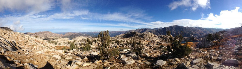
In the dark I climbed to a place I had found the previous day with a great view of the Minarets. The sunrise was spectacular!

After the sunrise I made my way back to camp where I was joined by Paul. He, once again, returned from fishing empty handed.

We took our time with breakfast and packing up camp since we were only going 5.5 miles to Garnet Lake. While we were cooking, the two hikers we had seen on Mt Ritter the day before walked by our camp and talked for a bit. They had climbed the lower cliffs route as I suspected.

Paul looking out over Garnet Lake

The hike to Garnet lake followed the John Muir Trail and was quite crowded, but went by fairly quickly. By 3pm we had crossed the ridge and found a place by the lake to set up camp. I spent the rest of the afternoon lounging by the lake watching Paul attempt to catch a fish…

After a couple of unsuccessful hours of fishing, we returned to camp for some dinner.

Disappointed that he didn’t have fresh fish for dinner, Paul went back for a second try as the sun was setting. Another half-hour of nothing and he was ready to call it a night, “Just one more throw.” Apparently that little statement was all it took. He hooked one!

With the sun gone and the stars out, it was time to call it a night.

(Photo Credit: Paul)

(Photo Credit: Paul)

Day 5: Garnet Lake to Silver Lake (August 26, 2012)

We awoke to a fairly cool, but clear, morning. The sun was climbing quickly as we made breakfast, but our camp was in the shadow of the ridge, so it was quite late in the morning before we felt the warmth of the sun’s rays.

We had about 7 miles to hike back to the car taking a slightly different path than we took on day one. We hiked directly to Agnew lake rather than repeating the loop around Gem lake.  But before leaving camp, Paul got in one more round of fishing.

Paul casting his line for the last time on this trip

We returned to Agnew lake through Spooky Meadow. The scenery here was different than any we had seen so far. The gray granite had been replaced by reddish lava rock and the meadow itself was strangely calm for how windy it was elsewhere on the trail.

Descending the steep slopes towards Agnew Lake

Leaving the meadow started us on a grueling 3,000ft descent over a short 3 miles of trail. By the end of the hike my feet and knees were sick of walking on the unsteady, fist-sized rocks that covered the trail. I was definitely glad to have not come up this route on day one.

Back at the car we celebrated a fun trip. Even though we didn’t reach our target summits, we returned from 5 days in the back country safely with plenty of good stories and pictures.

See more photos on Flikr!

Be sure to check out the first 3 days of the trip!

Day 1: Into the Wilderness

Day 2: In the High Sierra

Day 3: Mt Ritter Summit Day

Mt Ritter Summit Day

Day 3: Mt Ritter Summit Day (August 24, 2012)

The plan was to get up at 6:00am and be on the trail by 7:00am. Unfortunately, Paul’s watch alarm wasn’t loud enough to be heard outside of his sleeping bag. Despite this, we were on our way up the approach trail by 7:30am.

One of the many waterfalls along the approach trail

The trail made its way up to the R/B valley along a small stream that tumbled down many beautiful waterfalls.

We made it to the upper valley by 8:00am and made our way towards the lower chute. The sky was clear and we were already feeling the heat of the morning sun as we started up the chute.

The chute quickly steepened to class 2 as we climbed up the scree. It wasn’t too loose, though the occasional small rock would take a short tumble.

Looking out at Ediza Lake under the morning sun from the lower slopes of Mt Ritter

Grassy ledge leading out of the lower chute

We gained elevation quickly, and before long spotted our first landmark, the “tree rock”. Our route description said to avoid this and continue climbing.

A short ways above the “tree rock” I spotted a cairn on a ledge above us. We suspected this to be where we were to exit the chute, and sure enough, it led us to a nice grassy ledge. Traversing the grass ledge brought us into view of the SE pinnacle. From here we could scout our route, contouring beneath the pinnacle.

Our traverse under the pinnacle (just above 11,000ft) brought us across the first snow field of the climb. Crampons made crossing the 100yd stretch of snow fairly quick, but the mountain was very dry, and we were back on rock after only a few minutes.

From here we continued around the pinnacle, climbing our way to the base of Mt Ritter’s SE glacier. The sound of running water filled the air. We were surrounded by several  streams flowing down the mountain from the base of the glacier.

At the base of the SE glacier, we found ourselves standing on a large rocky plateau. With Mt Ritter and the glacier towering above, and Ediza Lake in the valley below, I couldn’t help but feel like a tiny speck on the side of this mighty mountain.

Standing at the base of the SE glacier with the SE pinnacle in the background (photo credit: Paul)

The glacier was a light icy blue and covered in dozens of steams flowing down the face. Rock fall had sprinkled the surface with dark boulders of all sizes. Midway up the right side of the glacier were the two chutes that we could take to the summit ridge. From route descriptions, Owens chute sounded like the easier climb, but with the low snow level, there was a significant stretch of wet rock slab that looked very slick. Below Owens chute was Secors chute. Though it is described as being a steeper climb, it wasn’t blocked by streams and slick rock.

Before continuing our climb, we stopped for a quick lunch. While sitting, we heard a loud crash come from high above. Looking to the top left of the glacier, we spotted a large rock, maybe the size of a dog house, take a pitch off the ridge and come bouncing and sliding down the face of the glacier! Fortunately we were not directly beneath its path, though it made its way fairly close to where we had been climbing up about half an hour earlier.

Paul standing at the opening of Secors Chute with the SE Glacier of Mt Ritter behind him

After lunch we loaded up and began the climb towards Secors chute.

The snow increased in steepness as we approached the base of the chute. Here, at the bottom of the chute, the snow stopped. We looked for a good place to get off the snow, but the chute was filled with very loose rock. I took two steps off the snow and could barely get purchase on the loose rock, sliding back towards the snow. Another step nearly kicked loose a large rock.

After a brief discussion, we decided that the lack of snow, and the loose rock made it unsafe for us to continue. We turned back…

Back at our lunch spot, we decided to try and descend the lower cliff via the grassy ledge route. We spotted a cairn to the left of the left-most stream, as mentioned by the route description, and made our way towards it. This led us to a second, and then a third cairn!

I was feeling good about this descent until we reached the third cairn. We were standing atop a cliff with no apparent way down. The route was supposed to be class 2 the whole way, but we were looking at a whole lot of class 4.

After looking at the pictures and a bit of debating, we determined that the cairns had led us to far over to be standing atop the lower cliffs. Because of the warmer season and quickly melting glacier, the left-most stream we had followed may not be there during normal years. We had to turn back.

It was now mid afternoon, and rather than continuing our route finding towards the lower cliffs, we returned the way we came. After traversing back under the SE Pinnacle, we spotted two people sitting on a grassy ledge below. They were tiny figures giving a grand perspective of the valley far below.

Continuing across the mountain, we returned to the chute we had climbed at the start of the day. From here the descent was strait forward.

Looking at Ediza Lake from the lower chute of Mt Ritter

Back on the valley floor we ditched the helmets and made our way back to camp. It was good to be back and get the boots off. A day of climbing over rocks had taken a toll on my feet.

On the descent we got a good look at the upper chute leading to the Ritter-Banner saddle. The snow did not go all the way to the top of this chute either. Thinking that it would lead us to more steep, loose rock like today, we decided not to attempt Banner the following day. Instead we would take two easy days before heading back to reality in the Bay Area.

Continue reading with Days 4 & 5 HERE!

Be sure to check out Days 1 & 2 of this adventure!

Day 1: Into the Wilderness

Day 2: In the High Sierra

Resources

Mt Ritter Summit Post

SE Glacier Route