 Along the northern coast of California is a stretch of land so rugged that the road crews constructing Highway 1 didn’t dare tackle it. This stretch is the Lost Coast. Here the land rises sharply from the sea, reaching heights of 4,000 feet within only 3 miles of the shore. Since this sort of geology is so rare along US coastline, it was an obvious destination!
The Lost Coast Trail stretches 26 miles from the mouth of the Mattole River to Shelter Cove. While the mileage is not great, there are two stretches that are impassable during high tide. Because of the need to cross these sections at low tide, it is best to make the trip in 3 days.
Thursday, May 17, 2012 – The Drive
We hit the road out of Berkeley at 3pm in an effort to beat the traffic. Our first destination was the Shelter Cove trailhead. Since we were doing a point-to-point hike, we took two cars to run a shuttle.
After about 3.5 hrs of driving, we turned off Highway 101 in Garberville, where we stopped for gas and a bite to eat. As we left the restaurant, a man working there stopped us to talk about the Lost Coast. He told us to keep our eyes open because we may “see some large tracks in the sand… or maybe some larger tracks…” He said this with a bit of humor in his voice, and I assumed he was referring to the tracks from bears and Bigfoot!

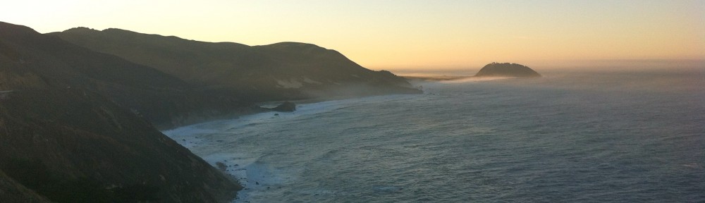
View from the parking lot at Shelter Cove
From here we headed to the coast along a winding country road and dropped off Paul’s car in Shelter Cove. Now, with 4 of us pilled in my car, we headed north. According to my GPS, the drive would take us back over the King Range to Ettersburg Rd. This would get us to the northern trailhead in about 1.5hrs.
However! Near the top of the ridge we passed King Peak Rd. Paul said that he remembered Google telling us to take this road. So, in defiance of my GPS, we took off down King Peak Rd.
This road is labeled on the map as being paved… it is not! It starts out as a nicely graded gravel fire road. All was going well until we came around a dark turn and found ourselves looking at a rather interesting stream crossing. The water wasn’t deep, but there was definitely a sharp dip getting into and out of the stream. After a bit of planning, and kicking everyone out to lighten the load, we went for it, and made it… but not without scraping both bumpers along the way.
With that behind us, we continued… how much worse could it really get? Two more tricky stream crossings later, we got to a fork in the road. Our path took a steep turn downhill, which included a significant rut about the width of my wheel base. While the Vibe had performed so well on the streams, this was definitely too much for it. Slightly misled by Google, we turned around.
Getting back out proved a bit trickier than getting in, but once we were back on paved road it was easy driving to the Mattole river. With our minor 2hr detour, we rolled into camp at the Mattole River Trailhead at 12:45am.
Friday, May 18th, 2012 – Mattole River to Spanish Flat
I woke up at 7:30am to a bright sky lighting up the tent, birds chirping, and a chill in the air. We had about 4 miles to hike before getting to the first impassable section, and high tide peaked at 11:15am. We left camp at about 9am with the goal of getting to the impassable section by lunch.

Starting our way south from the Mattole River
We started out hiking on the beach. The sand made this quite difficult, so we followed the trail just off the beach. It was nice walking on a surface that didn’t slip away beneath your feet with every step!
The sun was out and the views were amazing! Such a different environment than anything I had ever experienced….
As we continued down the coast, the wind picked up significantly. The strong gusts would occasionally catch my backpack like a sail and throw me off balance.
About 2 miles in, we arrived at the abandoned lighthouse, where we met three northbound hikers, who were using it as shelter from the wind while enjoying their lunch.

Abandoned lighthouse

Rocky land meets crashing waves, blocking our path down the beach
After passing the lighthouse, we reached the high tide section. The tide was on its way out, so we had plenty of room to hike. A short ways in, we reached a section of rock that stuck out into the ocean. With the waves crashing against the rock, we were left scrambling over steep scree in order to pass.
It was not easy going, but Charles ran up and over without giving it a second thought! He may have been a mountain goat in a past life…

Charles waiting up for those of us who aren’t in touch with our inner mountain goat
Past this section, it was back to the beach where we continued down the coast. At this point my feet and hips were really starting to feel the effect of hiking across miles of sand and fist sized rocks.
Once past the high tide section, we were able to get off the beach and back onto the trail. The trail took us across grassy meadows and through a few stream crossings. After pausing for a moment waiting for everyone to cross one stream, Paul took the lead and nearly stepped on a snake. I was a few steps behind him when he let out a good yelp and quickly turned to run in the other direction, nearly plowing me down in the process!

Paul pulling out the camera by the Spanish Ridge Trail
 As we approached Spanish Flat, we pasted a sign post marking the Spanish Ridge trail. The trail was completely overgrown, and without even a path through the grass where someone may have walked, it was clear that no one had traveled on it in quite some time. I suppose it’s a good thing we weren’t trying to take it…
Once at Spanish Flat we set up camp behind some trees to get shelter from the wind, which was still blowing hard. It was about 5pm, and it was time to make some food.
 As the evening went on, we made our way down to the beach to set up the cameras for the sunset. The wind had let up a bit, though a few strong gusts continued to throw sand at us.
 The sunset was beautiful! The sky over head was clear, and there were a few clouds on the horizon to give us some spectacular colors. We even saw a few whales swimming off in the distance.
Once the sun was down, the stars came out in full force. Every time I get out of the bay area, I’m amazed at how many stars are up there.

Sun set off the Lost Coast from Spanish Flat
Check out Part II of this trip HERE!
Check out more photos from this trip on Flickr
